Portal:Mount Everest
Introduction

Mount Everest, known in Nepali as Sagarmatha (सगरमाथा) and in Tibetan as Chomolungma (ཇོ་མོ་གླང་མ), is Earth's highest mountain above sea level, located in the Mahalangur Himal sub-range of the Himalayas. The international border between Nepal (Province No. 1) and China (Tibet Autonomous Region) runs across its summit point.
The current official elevation of 8,848 m (29,029 ft), recognized by China and Nepal, was established by a 1955 Indian survey and subsequently confirmed by a Chinese survey in 1975. In 2005, China remeasured the rock height of the mountain, with a result of 8844.43 m (29,017 ft). There followed an argument between China and Nepal as to whether the official height should be the rock height (8,844 m., China) or the snow height (8,848 m., Nepal). In 2010, an agreement was reached by both sides that the height of Everest is 8,848 m, and Nepal recognizes China's claim that the rock height of Everest is 8,844 m.
Selected general articles
 Precipitated by unexpected permission from Tibet, the 1935 British Mount Everest reconnaissance expedition was planned at short notice as a preliminary to an attempt on the summit of Mount Everest in 1936. After exceptionally rancorous arguments involving the Mount Everest Committee in London, Eric Shipton was appointed leader following his successful trekking style of expedition to the Nanda Devi region in India in 1934.
Compared with what had gone before and what followed it was a small, low-cost affair. The approach was from the north side of the mountain and the climbing was planned to be after the monsoon. The monsoon was unusually late that year and, beset by the weather and in difficult conditions of snow, little was achieved regarding the summit. However, a very large number of lesser peaks were climbed for the first time and a southern route up the Western Cwm was identified as a possible line of approach if Nepal could ever be persuaded to change its policy of not admitting climbers. Read more...
The Hornbein Couloir is a notable narrow and steep couloir high to the west on the north face of Mount Everest in Tibet, that extends from about 8,000 to 8,500 m (26,200 to 27,900 ft) elevation, 350 metres (1,150 feet) below the summit.
For the first 400 m (1,300 ft) vertical, the couloir inclines at about 47°, and the last 100 m (330 ft) is narrower and steeper with about a 60° average incline. To the east on the north face with less angle is the much larger Norton Couloir. Read more...
The Geneva Spur, named Eperon des Genevois and has also been called the Saddle Rib is a geological feature on Mount Everest—it is a large rock buttress near the summits of Everest and Lhotse. The Geneva spur is above Camp III and the Yellow Band, but before Camp IV and South Col. It is a spur near the south col. A related formation is the saddle (landform) between the peaks of Mount Everest and Lhotse.
The spur is between about 25,000 and 26,000 feet altitude. Read more...
Mount Everest, at 8,848 metres (29,029 ft) is the world's highest mountain and a particularly desirable peak for mountaineers. More than 297 people have died trying to climb it. The last year without known deaths on the mountain was 1977, a year in which only two people reached the summit.
Most deaths have been attributed to avalanches, injury from fall, ice collapse, exposure, frostbite, or health problems related to conditions on the mountain. Not all bodies have been located, so details on those deaths are not available. Read more...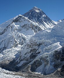
The 2006 Philippine Mount Everest expedition was the quest for the first Filipino's to climb Mount Everest, and to put the Philippine flag on top of the mountain. Read more...
During the afternoon of 25 April 2015, a MW 7.8 earthquake struck Nepal and surrounding countries. Shaking from the quake triggered an avalanche from Pumori into the basecamp on Mount Everest. At least twenty-two people were killed, surpassing an avalanche that occurred the previous year as the deadliest disaster on the mountain. Read more...- The Mount Everest Committee was a body formed by the Alpine Club and the Royal Geographical Society to co-ordinate and finance the 1921 British Mount Everest reconnaissance expedition to Mount Everest and all subsequent British expeditions to climb the mountain until 1947. It was then renamed the Joint Himalayan Committee; this latter committee organised and financed the successful first ascent of Mount Everest in 1953. Read more...
Pumori (Nepali: पुमोरि) (or Pumo Ri) is a mountain on the Nepal-Tibet border in the Mahalangur section of the Himalayas. Pumori lies just eight kilometres west of Mount Everest. Pumori, meaning "the Mountain Daughter" in Sherpa language, was named by George Mallory. "Pumo" means young girl or daughter and "Ri" means mountain in Sherpa language. Climbers sometimes refer to Pumori as "Everest's Daughter". Mallory also called it Clare Peak, after his daughter.
Pumori is a popular climbing peak. The easiest route is graded class 3, although with significant avalanche danger. Pumori was first climbed on May 17, 1962 by Gerhard Lenser on a German-Swiss expedition. Two Czechs (Leopold Sulovský and Zdeněk Michalec) climbed a new route on the south face in the spring of 1996. Read more...- Everest: Beyond the Limit is a Discovery Channel reality television series about yearly attempts to summit Mount Everest organized and led by New Zealander Russell Brice. Read more...
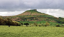 While growing up, Sharp summited North Yorkshire's Roseberry Topping, 320 m (1,050 ft) high.
David Sharp (15 February 1972 – 15 May 2006) was an English mountaineer who died near the summit of Mount Everest. His death caused controversy and debate, because he was passed by a number of other climbers heading to and returning from the summit as he was dying, although a number of others did try to help him.
Sharp had previously summitted Cho Oyu and was noted as being a talented rock climber, who seemed to acclimatize well, and was known for being in good humor around mountaineering camps. He had appeared briefly in season one of the television show Everest: Beyond the Limit, which was filmed the same season as his ill-fated expedition to Everest. Read more...
The South Col is the sharp-edged notch or pass between Mount Everest and Lhotse, the highest and fourth highest mountains in the world, respectively. When climbers attempt to climb Everest from the southeast ridge in Nepal, their final camp (usually Camp IV) is situated on the South Col. The South Col is typically swept by high winds, leaving it free of significant snow accumulation.
The South Col was first reached by Edouard Wyss-Dunant's 1952 Swiss Mount Everest Expedition that failed to reach the summit. The following year, when Mount Everest was first climbed, Wilfrid Noyce and the Sherpa Annullu were the first climbers on the expedition to reach the col. According to John Hunt, the expedition leader: Read more...- Into Thin Air: A Personal Account of the Mt. Everest Disaster is a 1997 bestselling non-fiction book written by Jon Krakauer. It details the author's experience at the 1996 Mount Everest disaster, in which eight climbers were killed and several others were stranded by a rogue storm. The author's expedition was led by guide Rob Hall, and there were other groups trying to summit on the same day, including one led by Scott Fischer, whose guiding agency, Mountain Madness, was perceived as a competitor to Rob Hall's agency, Adventure Consultants. Read more...
Everest base camps refers to two base camps on opposite sides of Mount Everest (It could also include any Everest base camp on a given route, but this is less common since the two main routes became standardized). South Base Camp is in Nepal at an altitude of 5,364 metres (17,598 ft) (), while North Base Camp is in Tibet at 5,150 metres (16,900 ft) (). These camps are rudimentary campsites on Mount Everest that are used by mountain climbers during their ascent and descent. South Base Camp is used when climbing via the southeast ridge, while North Base Camp is used when climbing via the northeast ridge.
Supplies are shipped to the South Base Camp by sherpas or porters, and with the help of animals, usually yaks. The North Base Camp has vehicle access (at least in the summer months). Climbers typically rest at base camp for several days for acclimatization to reduce the risks and severity of altitude sickness. Read more...- The Rongbuk Glacier (simplified Chinese: 绒布冰川; traditional Chinese: 絨布冰川; pinyin: Róngbù Bīngchuān) is located in the Himalaya of southern Tibet. Two large tributary glaciers, the East Rongbuk Glacier and the West Rongbuk Glacier, flow into the main Rongbuk Glacier. It flows north and forms the Rongbuk Valley north of Mount Everest. The famous Rongbuk Monastery is located at the northern end of the Rongbuk valley. Mount Everest is the source of the Rongbuk Glacier and East Rongbuk Glacier. Read more...
The 1924 British Mount Everest expedition was—after the 1922 British Mount Everest expedition—the second expedition with the goal of achieving the first ascent of Mount Everest. After two summit attempts in which Edward Norton set a world altitude record of 28,126 feet (8572m), the mountaineers George Mallory and Andrew "Sandy" Irvine disappeared on the third attempt. Their disappearance has given rise to the long-standing unanswered question of whether or not the pair climbed to the summit. Mallory's body was found in 1999 at 26,760 feet (8155 m), but the resulting clues did not provide conclusive evidence as to whether the summit was reached. Read more...
Mount Everest guides are people who help people to climb Mount Everest in the Himalayas.
Guides can, for example, set fixed lines of rope for others to use, organize rescues in times of trouble, or use communication tools to call in helicopter evacuations. Another job on Mount Everest is as an "icefall doctor" using ladders and ropes to make a path across the Khumbu Icefall, which guides might do themselves or delegate to others. Guides, especially if they are guiding for a mountaineering or adventure company, often call the people they help up "clients". Read more...
The Mount Everest climbing season of 2012 included several hundred summitings and the highest fatality total since 1996. 683 climbers from 34 countries attempted to climb the mountain, and 547 people summited. A record was set in May when 234 climbers summitted on a single day. There were 11 deaths, some of which were attributed to overcrowding near the peak. Read more...- Everest is a 70mm American documentary film, from MacGillivray Freeman Films, about the struggles involved in climbing Mount Everest, the highest mountain peak on Earth, located in the Himalayan region of Nepal. It was released to IMAX theaters in March 1998 and became the highest-grossing film made in the IMAX format. Read more...
The Khumbu Icefall is an icefall located at the head of the Khumbu Glacier and the foot of the Western Cwm, which lies at an altitude of 5,486 metres (17,999 ft) on the Nepali slopes of Mount Everest, not far above Base Camp and southwest of the summit. The icefall is considered one of the most dangerous stages of the South Col route to Everest's summit. Read more...
The Mount Everest climbing season of 2013 included 658 summits and 8 deaths. Due to avalanches in 2014 and 2015, this was the last big summiting year until 2016. Read more...- The 2007 Altitude Everest expedition, led by the American climber Conrad Anker, arrived at Base Camp below the north face of Everest in May 2007 and retraced the last journey of British climber George Mallory. On 8 June 1924, Mallory, along with his climbing partner Andrew Irvine, set out for the summit of Everest but disappeared from view short of the summit. The mystery of whether they could have been the first climbers to reach the world's highest point has never been resolved. Anker and his colleagues investigated what happened to them, testing out the durability of their clothing and equipment to establish whether Mallory and Irvine could have reached the summit in the conditions they faced in 1924. Read more...
The Kangshung Face or East Face is the eastern-facing side of Mount Everest, one of the Chinese sides of the mountain. It is 3,350 metres (11,000 ft) from its base on the Kangshung Glacier to the summit. It is a broad face, topped on the right (when seen from below) by the upper Northeast Ridge, and on the left by the Southeast Ridge and the South Col. Most of the upper part of the face is composed of hanging glaciers, while the lower part consists of steep rock buttresses with couloirs between them. It is considered to be a dangerous route of ascent, compared to the standard North Col and South Col routes, and it is the most remote face of the mountain, with a longer approach. Read more... The official logo of the Earth Day 20 International Peace Climb
The Earth Day 20 International Peace Climb was an expedition to reach the summit of Mount Everest during Earth Week 1990 led by Jim Whittaker, the first American to climb Mount Everest (in 1963), and marked the first time in history that mountaineers from the United States, Soviet Union and China had roped together to climb a mountain, let alone Mount Everest.
The expedition's name was from its partnership with the Earth Day 20 Foundation, an organization celebrating the 20th anniversary of Earth Day that was led by Edward Furia. The climbers highlighted their expedition with a live satellite phone call to President George H.W. Bush as well as to Furia, Earth Day 20 organizers and thousands of supporters gathered in George, Washington, near the Columbia River on April 22, 1990. Whittaker called from base camp to pledge his support for world peace and attention to environmental issues. Read more...- Everest is a Hindi language Indian telenovela which began airing on STAR Plus on 3 November 2014. The series was created by Ashutosh Gowariker and produced by Ashutosh Gowariker Productions Private Limited (AGPPL). The music of the telenovela was composed by A. R. Rahman. It was shot in India and Nepal. The shooting locations included Everest Base Camp (in Nepal) and the Dokriani Glacier (in India), which are located at a height of 17,590 feet (5,360 m) and 12,000 feet (3,700 m) above sea level, respectively. Read more...
Nuptse or Nubtse (Sherpa: ནུབ་རྩེ། नुबचे, Wylie: Nub rtse) is a mountain in the Khumbu region of the Mahalangur Himal, in the Nepalese Himalayas. It lies two kilometres WSW of Mount Everest. Nubtse is Tibetan for "west peak", as it is the western segment of the Lhotse-Nubtse massif.
The summit of Nuptse is extremely dangerous due to loose snow with a lot of hollows, and there are also weakly attached cornices of snow. This provides a barrier to climbing, yet is not sturdy enough for safe climbing. Read more...
The 1996 Mount Everest disaster occurred on 10–11 May 1996, when eight people caught in a blizzard died on Mount Everest during attempts to descend from the summit. Over the entire season, 12 people died trying to reach the summit, making it the deadliest season on Mount Everest before the 16 fatalities of the 2014 Mount Everest avalanche and the 22 deaths resulting from avalanches caused by the April 2015 Nepal earthquake. The 1996 disaster gained wide publicity and raised questions about the commercialization of Everest.
Numerous climbers, including several large teams as well as some small partnerships and soloists, were high in altitude on Everest during the storm. While climbers died on both the North Face and South Col approaches, the events on the South Face were more widely reported. Journalist Jon Krakauer, on assignment from Outside magazine, was in a party led by guide Rob Hall that lost four climbers on the south side; he afterwards published the bestseller Into Thin Air (1997), which related his experience. Anatoli Boukreev, a guide in Scott Fischer's party (which lost Scott Fischer, but no clients), felt impugned by Krakauer's book and co-authored a rebuttal book called The Climb: Tragic Ambitions on Everest (1997). Beck Weathers, of Hall's expedition, and Lene Gammelgaard, of Fischer's expedition, wrote about their experiences of the disaster in their respective books, Left For Dead: My Journey Home from Everest (2000) and Climbing High: A Woman's Account of Surviving the Everest Tragedy (2000). In 2014, Lou Kasischke, also of Hall's expedition, published his own account of the tragedy in After the Wind: 1996 Everest Tragedy, One Survivor's Story (2014). Mike Trueman, who coordinated the rescue from Base Camp, has added to the story with The Storms: Adventure and Tragedy on Everest (May 2015). Graham Ratcliffe, who climbed to the South Col of Everest on 10 May, has documented in A Day To Die For (2011) that weather reports delivered to expedition leaders including Rob Hall and Scott Fischer before their planned summit attempts on 10 May forecast a major storm developing after 8 May and peaking in intensity on 11 May. As Hall and Fischer planned their summits for 10 May, portions of their teams summitted Everest during an apparent break in this developing storm only to descend into the full force of it late on 10 May. Read more...
The Kangshung Glacier is one of the three main glaciers of Mount Everest, and is in the Tibet region Himalayas, within the Tibet Autonomous Region of China. The other two are the Khumbu Glacier and Rongbuk Glacier. Read more...- The 1960 Chinese Mount Everest expedition was the first to successfully ascent Mount Everest via the North Ridge. Three members of the Chinese Everest Expedition Team, Wang Fuzhou, Gonpo, and Qu Yinhua reached the summit at 4:20 a.m., 25 May. The expedition left no photographic evidence at the summit, and was originally met with skepticism in the West. However, the international mountaineering community has generally acknowledged the result as more evidence has been revealed. Read more...
 Mount Everest's Southwest Face. Nuptse obscures the view at the lower right.
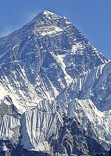
The 1975 British Mount Everest Southwest Face expedition was the first to successfully climb Mount Everest by ascending one of its faces. In the post-monsoon season Chris Bonington led the expedition which used rock climbing techniques to put fixed ropes up the face from the Western Cwm to just below the South Summit. A key aspect of the success of the climb was the scaling of the cliffs of the Rock Band at about 8,200 metres (27,000 ft) by Nick Estcourt and Tut Braithwaite. Two teams then climbed to the South Summit and followed the Southeast Ridge to the main summit – Dougal Haston with Doug Scott on 24 September 1975, who at the South Summit made the highest ever bivouac for that time, and Peter Boardman with Pertemba two days later. It is thought that Mick Burke fell to his death shortly after he had also reached the top. British climbers reached the summit of Everest for the first time in an event that has been described as "the apotheosis of the big, military-style expeditions". Read more... Mount Everest from the northern side. The snowy peak catching light in front of Everest is Changtse.
Mount Everest, at 8,848 metres (29,029 ft) is currently the world's highest mountain range and has now become a particularly desirable peak for mountaineers. This is a list of people who reached the summit of Mount Everest in the 20th century. Overall about 1,383 people summited Everest between 1953 and the end of 2000. After 2000, the number of summiters greatly increased when ascending the mountain became more accessible and more popular. By 2013, 6,871 summits had been recorded by 4,042 different people. Read more...
The list consists of people who reached the summit of Mount Everest more than once. By 2013, 6,871 summits have been recorded by 4,042 different people. Despite two hard years of disaster (2014 and 2015), by the end of 2016 there were 7,646 summits by 4,469 people. In 2018 about 800 people summited, breaking the record for most in one year compared to 2013, in which 667 summited Mount Everest.
Note all information may not be completed/updated, it can take months and even years to update summit counts as confirmed by sources Read more...- The goal of the Mallory and Irvine Research Expedition of 1999 was to discover evidence of whether George Mallory and Andrew Irvine had been the first to summit Mount Everest in their attempt of 8–9 June 1924. The expedition was organised by regular Everest expedition leader Eric Simonson and advised by researcher Jochen Hemmleb, with a team of climbers from the United States, the United Kingdom, and Germany. Hemmleb's investigations of sketchy reports of earlier sightings and photographs had led him to identify what he believed was the area in which Irvine's body lay, some distance below where his ice axe had been found by Percy Wyn-Harris on the expedition led by Hugh Ruttledge in 1933. The team hoped in particular to find a camera on Irvine's body which, had the pair been successful, should have contained a picture of the summit. Within hours of commencing the search on 1 May 1999, Conrad Anker found a body on the North Face, at 8,155 m; but to their surprise it was that of Mallory, not Irvine.
Mallory lay face-down, arms outstretched as if to break a sliding fall, with one broken leg and a serious wound to the skull, but otherwise very well-preserved. It seemed probable that he had been a victim of a fall while roped to Irvine. The body was only an hour or two from the safety of their camp. Read more... 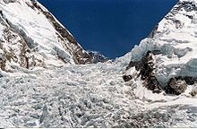 The Khumbu Icefall in 2005. The ice avalanche came from a serac failure from an ice bulge on Mount Everest's western shoulder (centre left), above the icefall.
On 18 April 2014, seracs on the western spur of Mount Everest failed, resulting in an ice avalanche that killed sixteen climbing Sherpas in the Khumbu Icefall. This was the same icefall where the 1970 Mount Everest disaster had taken place. Thirteen bodies were recovered within two days, while the remaining three were never recovered due to the great danger of performing such an expedition. Many Sherpas were angered by what they saw as the Nepalese government's meager offer of compensation to victims' families, and threatened a protest or strike. On 22 April, the Sherpas announced they would not work on Everest for the remainder of 2014 as a mark of respect for the victims. Read more...
Green Boots is the name given to the unidentified corpse of a climber that became a landmark on the main Northeast ridge route of Mount Everest. Though his identity has not been officially confirmed, he is believed to be Tsewang Paljor, an Indian climber who died on Mount Everest in 1996. The term Green Boots originated from the green Koflach mountaineering boots that are on the feet of the corpse. All expeditions from the north side encountered the body curled in the limestone alcove cave at 8,500 m (27,900 ft). In 2006, a different climber, David Sharp, died during a solo climb in what is known as "Green Boots' Cave".
In May 2014, Green Boots was reported missing, presumably removed or buried. In 2017, as a greater number of climbers returned, according to 2-stage hearsays he was noticed again at the same altitude and may have simply been covered with a few stones. Read more... Lho La behind where the Khumbu Icefall turns to become the Khumbu glacier. Behind are Changtse and Everest's West Ridge
The Lho La is a col on the border between Nepal and Tibet north of the Western Cwm, near Mount Everest. It is at the lowest point of the West Ridge of the mountain at a height of 6,006 metres (19,704 ft). Read more...
Lingtren, 6,749 metres (22,142 ft), is a mountain in the Mahalangur Himal area of Himalaya, about 8 kilometres (5.0 mi) distant in a direct line from Mount Everest. It lies on the international border between Nepal and the Tibet Autonomous Region of China and it was first climbed in 1935. A mountain nearby to the west was originally named Lingtrennup but is now more commonly called Xi Lingchain. Read more...
The 1933 British Mount Everest expedition was, after the reconnaissance expedition of 1921, and the 1922 and 1924 expeditions, the fourth British expedition to Mount Everest and the third with the intention of making the first ascent.
Like the previous expeditions to climb the mountain, the 1933 expedition was unsuccessful, although in two separate attempts Lawrence Wager and Percy Wyn-Harris, and then F. S. Smythe, set an altitude record for climbing without supplemental oxygen that was not broken until Reinhold Messner and Peter Habeler reached the summit of Mount Everest in 1978. During Wager and Wyn-Harris's attempt, the ice-axe belonging to Andrew Irvine, who disappeared with Mallory on the 1924 attempt while going for the summit, was found on the flanks of the north face. Read more...- The 1951 British Mount Everest reconnaissance expedition ran between 27 August 1951 and 21 November 1951 with Eric Shipton as leader.
The expedition reconnoitred various possible routes for climbing Mount Everest from Nepal concluding that the one via the Khumbu Icefall, Western Cwm and South Col was the only feasible choice. This route was then used by the Swiss in their two expeditions in 1952 followed by the successful ascent by the British in 1953. Read more...  Mount Everest. The route the British took started up the Khumbu Icefall − seen spilling out of the Western Cwm (hidden from view) − then climbed the Lhotse Face and reached the South Col (snowy depression, extreme right), finishing up the south-east ridge (right-hand skyline)
The 1953 British Mount Everest expedition was the ninth mountaineering expedition to attempt the first ascent of Mount Everest, and the first confirmed to have succeeded when Edmund Hillary and Tenzing Norgay reached the summit on Friday, 29 May 1953. Led by Colonel John Hunt, it was organised and financed by the Joint Himalayan Committee. News of the expedition's success reached London in time to be released on the morning of Queen Elizabeth II's coronation, 2 June. Read more...- After World War II, with Tibet closing its borders and Nepal becoming considerably more open, Mount Everest reconnaissance from Nepal became possible for the first time culminating in the successful ascent of 1953. In 1950 there was a highly informal trek to what was to become Everest Base Camp and photographs were taken of a possible route ahead. Next year the 1951 British Mount Everest reconnaissance expedition reconnoitred various possible routes to Mount Everest from the south and the only one they considered feasible was the one via the Khumbu Icefall, Western Cwm and South Col. In 1952, while the Swiss were making an attempt on the summit that nearly succeeded, the British practised their high-altitude Himalayan technique by attempting Cho Oyu, nearby to the west. Read more...
The 1921 British Mount Everest reconnaissance expedition set off to explore how it might be possible to get to the vicinity of Mount Everest, to reconnoitre possible routes for ascending the mountain, and – if possible – make the first ascent of the highest mountain in the world. At that time Nepal was closed to foreigners, so any approach had to be from the north, through Tibet. A feasible route was discovered from the east up the Kharta Glacier and then crossing the Lhakpa La pass north east of Everest. It was then necessary to descend to the East Rongbuk Glacier before climbing again to Everest's North Col. However, although the North Col was reached, it was not possible to climb further before the expedition had to withdraw.
Initially the expedition explored from the north and discovered the main Rongbuk Glacier, only to find that it seemed to provide no likely routes to the summit. However, at the time it was not realised that the East Rongbuk glacier actually flowed into the Rongbuk glacier – it was thought it descended away to the east. Read more...- Led by Bill Tilman, the 1938 British Mount Everest expedition was a low-key, low-cost expedition which was unlucky in encountering a very early monsoon. The weather conditions defeated the attempts to reach the summit. The North Col was climbed for the first time from the west and an altitude of 27,200 feet (8,300 m) was reached on the North Ridge. Read more...
The South Summit of Mount Everest in the Himalayas is the second-highest peak on Earth, and is a subsidiary peak to the primary peak of Mount Everest. Although its elevation above sea level of 8,749 metres (28,704 ft) is higher than the second-highest mountain on Earth, K2 (whose summit is 8,611 metres (28,251 ft) above sea level), it is only considered a separate peak and not a separate mountain as its prominence is only 11 meters.
The peak is a dome-shaped peak of snow and ice, and is connected to the summit of Mount Everest by the Cornice Traverse and Hillary Step. It was first climbed by Charles Evans and Tom Bourdillon on the 1953 British Mount Everest expedition, on May 26, 1953. They were unable to continue on to the primary summit, but Edmund Hillary and Tenzing Norgay, the next pair to make a summit bid, traversed the South Summit to reach the main peak. The distance separating the two summits is approximately 130 metres (430 ft). Read more...


.jpg)


.jpg)
Did you know...
- ... that since the Beatles' audio engineer Geoff Emerick used to smoke Everest cigarettes, Abbey Road was originally planned to be titled Mount Everest, Everest or Ever Rest?
Need help?
Do you have a question about Mount Everest that you can't find the answer to?
Consider asking it at the Wikipedia reference desk.
Selected images

A yak at around 4790 m (15,715 ft)

Kangshung Face (the east face) as seen from orbit

Small avalanche on Everest, 2006
%2C_p._346.jpg/120px-%22Papers_relating_to_the_Himalaya_and_Mount_Everest%22_in_Proceedings_of_the_Royal_Geographical_Society_of_London%2C_Vol._I_(1857)%2C_p._346.jpg)
The name "Mount Everest" was first proposed in this 1856 speech, later published in 1857, in which the mountain was first confirmed as the world's highest

Available oxygen at Everest

The Khumbu Icefall in 2005

Selfie on the summit, 2012

Ascents of Mount Everest by year through 2010

The location of the fatal ice avalanche on the 2014 route, and the revised 2015 route through the Khumbu.
.jpg/120px-The_World’s_Tallest_Mountain_(15473492788).jpg)
Top down view showing the location of the summit, and its three main faces/sides

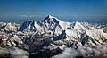
Mount Everest north face from Rongbuk in Tibet

1952 documentary
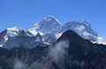
Mount Everest, May 2016, with Nuptse and Lhotse peaks to the upper right
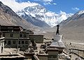
The Rongphu Monastery, with Mount Everest in the background
.jpg/120px-Nepal_2018-03-27_(40012222680).jpg)
Mount Everest in the upper left (March 2018)

Confirmation of the summit obtained by the Nepalese Ministry of Tourism

Mount Everest relief map

Mount Everest, 2014
Climbers below the Geneva Spur

Climber at the summit wearing an oxygen mask

A paraglider at Neustift, Tirol, Austria

From Kala Patthar

The sun rising on Everest in 2011

Overview South Col route and North Col/Ridge route
Published by the Survey of Nepal, this is Map 50 of the 57 map set at 1:50,000 scale "attached to the main text on the First Joint Inspection Survey, 1979–80, Nepal-China border." At the top centre, a boundary line, identified as separating "China" and "Nepal", passes through the summit contour. The boundary here and for much of the China-Nepal border follows the main Himalayan watershed divide.

A view from the summit of Mount Everest in May 2013
Mount Everest with snow melted, showing upper geologic layers in bands.

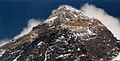
The summit of Mount Everest from the North side

A comparison of a Mount Everest height comparison with several other peaks. Note: Mount Sharp is on planet Mars; it is the one with Curiosity (rover).

Everest, April 2015


1890 graphic with the Himalayas, including Gaurisankar (Mount Everest) in the distance

Reunion of the 1953 British team
.jpg/120px-Nepal_-_Sagamartha_Trek_-_170_-_Gorak_Shep_(497708037).jpg)
Gorak Shep is about a three-hour walk to South EBC (Everest Base Camp).

Annotated image of Everest and surroundings as seen from Gokyo Ri.
Changtse, Nirekha, Everest, Lobuche West, Cho La, Nuptse, Lhotse, Lobuche, Island Peak.jpg/120px-Hillery_Step_near_Everest_Top_(retouched).jpg)
Looking up along the southern ridgeline, the face of the Hillary Step is visible. The top of the South-West face is on the left in shadow, and in the light to the right is the top of the East/Kangshung face. In 2016 and 2017 there were serious reports that the Hillary Step was changed, which triggered a big discussion in the climbing community. (2010 photo)

Everest in September 2006

The Western Cwm ("Coom"), with Everest on the left and Lhotse to the right
Aerial photo from the south, with Mount Everest rising above the ridge connecting Nuptse and Lhotse

Satellite view of Everest, Khumbu Glacier, Khumbu Icefall

Everest base camp

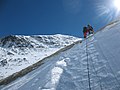
Climber traversing Khumbu Icefall

Photo of a Eurocopter AS350 B3 "Squirrel"
.jpg/120px-Nepal_2018-03-27_(26951480687).jpg)
Zoom on Everest summit (March 2018)

Everest and Lhotse from the south. In the foreground are Thamserku, Kantega, and Ama Dablam

,_p._346.jpg)


.jpg)


.jpg)


.jpg)

.jpg)


.jpg)

Subcategories
- Select [►] to view subcategories