Everest base camps


Everest base camps refers to two base camps on opposite sides of Mount Everest (It could also include any Everest base camp on a given route, but this is less common since the two main routes became standardized). South Base Camp is in Nepal at an altitude of 5,364 metres (17,598 ft) (28°0′26″N 86°51′34″E / 28.00722°N 86.85944°E), while North Base Camp is in Tibet at 5,150 metres (16,900 ft)[1][2][3] (28°8′29″N 86°51′5″E / 28.14139°N 86.85139°E). These camps are rudimentary campsites on Mount Everest that are used by mountain climbers during their ascent and descent. South Base Camp is used when climbing via the southeast ridge, while North Base Camp is used when climbing via the northeast ridge.[4]
Supplies are shipped to the South Base Camp by sherpas or porters, and with the help of animals, usually yaks. The North Base Camp has vehicle access (at least in the summer months). Climbers typically rest at base camp for several days for acclimatization to reduce the risks and severity of altitude sickness.
Contents
South Base Camp in Nepal[edit]

The Everest Base Camp trek on the south side is one of the most popular trekking routes in the Himalayas and is visited by thousands of trekkers each year. Trekkers usually fly from Kathmandu to Lukla to save time and energy before beginning the trek to this base camp. However, trekking to Lukla is possible. There are no roads from Kathmandu to Lukla and as a result, the only method of transporting large and heavy goods is by plane.
In 2015, it was noted that about 40,000 people per year take the trek from the Lukla airport to the Nepal Everest Base Camp.[5]

From Lukla, climbers trek upward to the Sherpa capital of Namche Bazaar, 3,440 metres (11,290 ft), following the valley of the Dudh Kosi river. It takes about two days to reach the village, which is a central hub of the area. Typically at this point, climbers allow a day of rest for acclimatization. They then trek another two days to Dingboche, 4,260 metres (13,980 ft) before resting for another day for further acclimatization. Another two days takes them to Everest Base Camp via Gorakshep, the flat field below Kala Patthar, 5,545 metres (18,192 ft) and Mt. Pumori.
On 25 April 2015, an earthquake measuring 7.8 on the moment magnitude scale, struck Nepal and triggered an avalanche on Pumori that swept through the South Base Camp.[6] At least 19 people were said to have been killed as a result. Just over two weeks later, on May 12, a second quake struck measuring 7.3 on the Mw.[7] Some of the trails leading to Everest Base Camp were damaged by these earthquakes and needed repairs.[5]

A temporary tent platform on the Khumbu glacier at South EBC, Nepal.
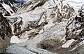
Nepal's EBC bottom left, Khumbu icefall to the right

Khumbu icefall
.jpg/120px-Everest_base_camp(1).jpg)
Everest Base Camp


.jpg)

North Base Camp in Tibet[edit]
A visit to the North (China-side) Base Camp currently requires a permit from the Chinese government, on top of the permit required to visit Tibet itself. Such permits must be arranged via travel companies in Lhasa as part of a package tour that include hiring a vehicle, driver, and guide. The North Base Camp is accessed by vehicle through a 100 km road branching to the South from the Friendship Highway near Shelkar. From the Base Camp, all tourists must take the buses managed by the government to limit the traffic in the last stretch of gravel road to a marked hill at 5,200 meters above sea level just before the climbers’ camp. It is also possible to trek up from the tourist camp, but only when properly acclimatized.[8] The "tourist Base Camp" is located about halfway between Rongbuk Monastery; the actual climbers' Base Camp is at the foot of Rongbuk glacier.

Gravel road leading to north EBC after leaving Friendship Highway, Tibet, with first close view of Mt. Everest
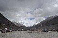
Tent village established for tourists' convenience called Everest Base Camp, in Tibet. It is the furthest that private cars can go. Mount Everest can be seen in the background.

Tea house at the North Everest Base Camp. Mount Everest is visible in the background.

Interior of tea house/hotel located at Everest Base Camp, Tibet

A view of Everest North (Tibet-side) Base Camp looking west, August 3, 2002. The permanent structure at left is for mountain climbers, central-left structure is for pit toilets, while the temporary wood-frame, plastic tarpaulin-covered structures below and right are for other visitors and support people

Climbers' tents in the restricted area beyond the area open to tourists.

Camps visible on northeast ridge as seen from north tent village, Tibet on May 20, 2011.


See also[edit]
 Everest Base Camp Trek travel guide from Wikivoyage
- Gorakshep
- List of Mount Everest expeditions

References[edit]
- ^ Foster, Simon; Jen Lin-Liu; Sherisse Pham; Sharon Owyang; Beth Reiber; Lee Wing-Sze; Christoper D. Winnan (2010). Frommer's China. John Wiley & Sons, 2010. p. 5. ISBN 9780470526583. Retrieved 2012-04-03.
- ^ Reynolds, Kev (2006). Everest - A trekker's guide. Cicerone Press Limited. p. 231. ISBN 978-1-84965-076-2. Retrieved 2012-04-03.
- ^ Buckley, Michael (2008). Shangri-La: A Travel Guide to the Himalayan Dream. Bradt Travel Guides. p. 165. ISBN 9781841622040. Retrieved 2012-04-03.
- ^ Mayhew, Bradley; Bindloss, Joe (2009). Trekking in the Nepal Himalaya. Lonely Planet. ISBN 978-1741041880.
- ^ a b 4 sections of trekking route to Mount Everest were damaged by earthquake, assessment finds
- ^ "Everest Base Camp a 'War Zone' After Earthquake Triggers Avalanches". National Geographic. Retrieved 26 April 2015.
- ^ "Avalanche triggered by quake kills 18 on Mount Everest access-date=26 April 2015".
- ^ "Which Everest Base Camp: Everest or Nepal?".
External links[edit]
| Wikimedia Commons has media related to Everest Base Camp. |
- Map: Everest Base Camp Map
- Mt. Pumori EBC Panorama
- Video: Avalanche hitting Everest Base Camp
- Altitude Profile of Everest Base camp trek
- GPS coordinates of EBC trek and description of the EBC trek

